The Surprising Parts of Tokyo Prefecture: Majestic Mountains to Faraway Islands
March 29, 2026 8:44 pm Leave your thoughtsWhen people hear “Tokyo,” most imagine neon signs, packed trains, and the famous Shibuya Crossing. The image is so strong that it almost completely hides a geographical fact: administratively, Tokyo is not just a megapolis but an entire prefecture stretching from mountains over two thousand meters high to subtropical islands in the middle of the Pacific Ocean.
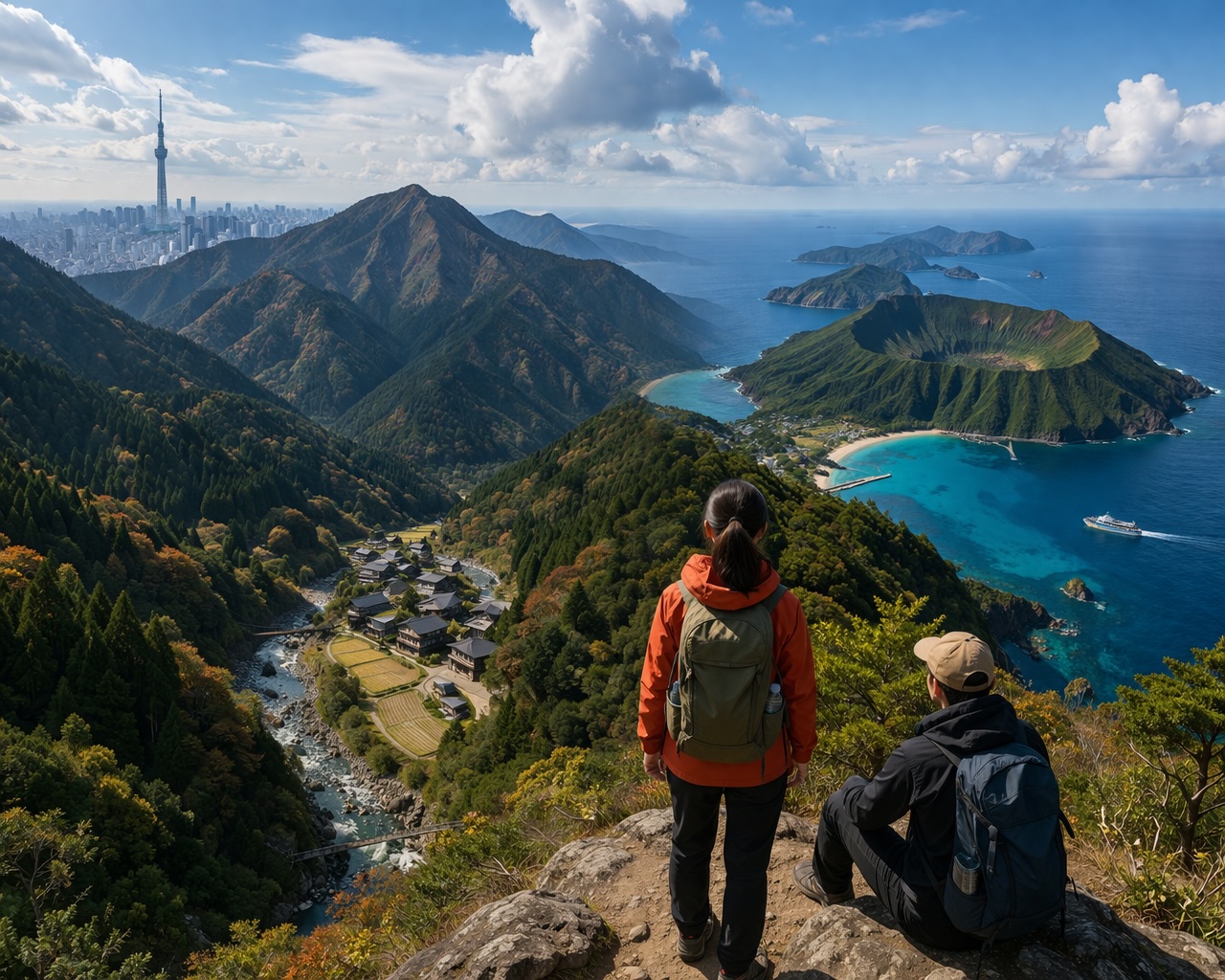
Japan’s capital actually contains several different worlds that rarely appear in tourist brochures. If you leave the central districts and continue west or south, the city gradually dissolves into forests, villages, volcanoes, and ocean horizons. This is the other Tokyo – a place that looks closer to a nature documentary than to a sci‑fi vision of the future.
The Mountains of the Capital
Only two hours by train from the skyscrapers of Shinjuku begins the Okutama region – the western, mountainous part of the prefecture. There, asphalt slowly gives way to cedar forests, rivers of cold mountain water, and small communities whose daily life has hardly changed for decades.
The region is part of Chichibu-Tama-Kai National Park and is one of the most unexpected faces of the capital. Tourists come for trekking, camping, or simply for “shinrin-yoku” – the Japanese practice of forest bathing. Within the borders of the same administrative unit that governs the largest urban agglomeration in the world live deer, wild monkeys, and even black bears.
Tokyo’s highest point – Mount Kumotori – reaches 2017 meters. This means a person can have breakfast in a business district and, by the afternoon, be climbing an alpine trail without ever formally leaving the capital.
This closeness between megapolis and wild nature is no coincidence. Japanese administrative thinking rarely draws a sharp line between center and periphery. Instead, the city gradually “thins out” until it becomes mountain.
Tokyo That Floats in the Ocean
The real surprise comes when we look south. Hundreds of kilometers from the skyscrapers lie islands that are also part of Tokyo Prefecture.
The Izu Islands chain is a series of volcanic islands accessible by ferry or small aircraft. Some are known for their surf culture, others for hot springs and dramatic rocky shores. On Mikurajima Island, for example, visitors can swim with wild dolphins – an experience hard to associate with the image of a global financial capital.
Even farther away sits the Ogasawara Islands archipelago, located about a thousand kilometers south of mainland Japan. Because of its unique flora and fauna, the region is often called the “Japanese Galápagos.” Here the climate is subtropical, palms grow, and the ocean is home to whales and coral reefs.
The paradox is almost surreal: one and the same local administration is responsible both for the most densely populated urbanized area on the planet and for isolated island ecosystems reachable only after a 24‑hour sea journey.
How Such a Different “City” Came to Be
Historically, Tokyo developed not only as a capital but as an administrative metropolis. After World War II, the Tokyo Metropolitan Government system united urban districts, western towns, and island territories under one structure. The result is unique: a megapolis that is not limited by its own urbanization.
This helps explain why the Japanese often perceive nature not as the opposite of the city but as its extension. In the Japanese imagination, modernity and tradition coexist – bullet trains depart toward mountains with ancient temples, and tropical islands are governed by the same capital that symbolizes the technological future.
The Capital as a Miniature Japan
The unusual parts of Tokyo Prefecture reveal something deeper than geographic curiosity. They show how Japan manages to combine extreme urbanization with a strong connection to nature, without one destroying the other.
Tokyo does not end where the skyscrapers stop. It continues into cedar forests, mountain peaks, volcanic craters, and distant ocean islands. Perhaps this is why the city feels so resilient – because behind the image of an endless megapolis stands a territory that resembles an entire country in miniature.
This post was written by rado